

 |
Surface Mount Multi Constellation GNSS Navigation System 10000 Hours MTBF
Product Details:
| Place of Origin: | China |
| Brand Name: | BTSTC |
| Certification: | CE |
| Model Number: | INS70S |
Payment & Shipping Terms:
| Minimum Order Quantity: | 1 |
|---|---|
| Price: | Negotiable |
| Packaging Details: | box and sponge |
| Delivery Time: | 7 days for sample |
| Payment Terms: | T/T |
| Supply Ability: | 1000/month |
|
Detail Information |
|||
| Application: | Tactical Weapons | Mtbf: | 10000 Hours |
|---|---|---|---|
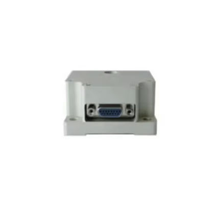
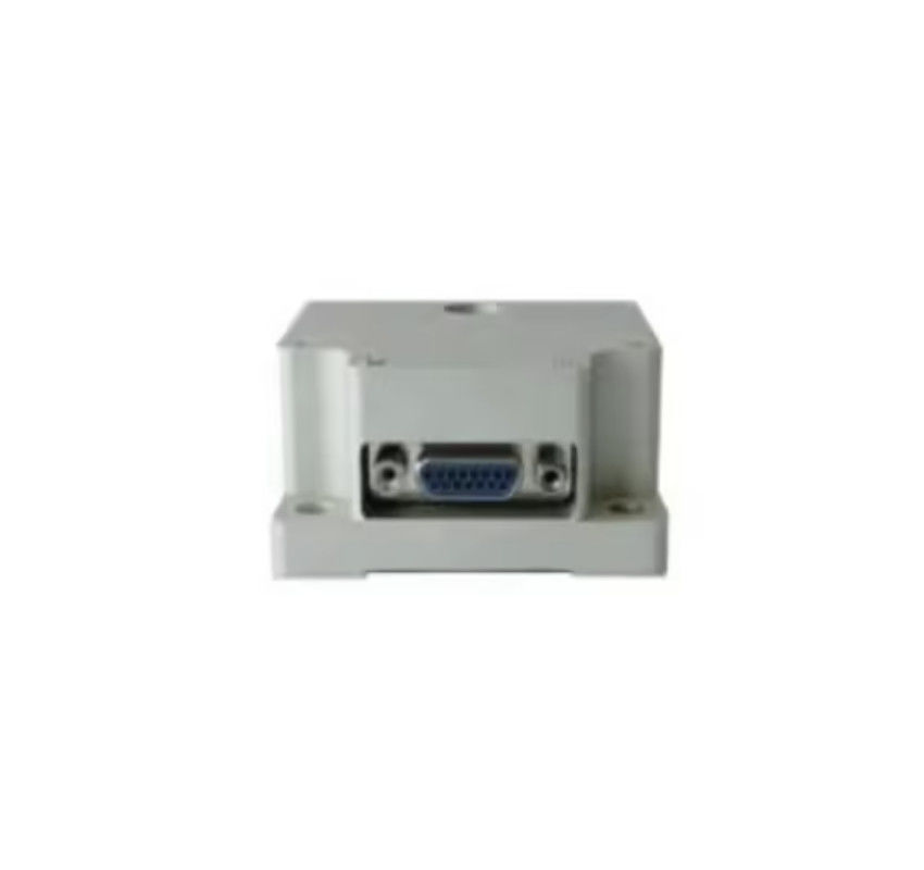
| Position Accuracy: | 5m (RMS) | Mounting: | Surface Mount |
| Speed Accuracy: | <0.15m / S (RMS) | Sensors: | Accelerometer, Gyroscope, Magnetometer |
| Attitude Angle Error: | ≤2° | Positioning: | Multi-constellation GNSS |
| Highlight: | gnss navigation system 10000 hours mtbf,surface mount gnss navigation system,surface mount integrated navigation system |
||
Product Description
Surface Mount Multi Constellation GNSS Navigation System 10000 Hours MTBF <0.15m/s Speed Accuracy
Product Description:
The Integrated Navigation System (INS) represents a breakthrough in navigational technology, offering a cost-effective solution without compromising on quality and efficiency. Designed to cater to both military and commercial applications, this system promises high reliability and performance. Its robust construction and advanced technological integration make it one of the most versatile systems on the market today. With an impressive Mean Time Between Failures (MTBF) of 10,000 hours, this system is built to last and perform consistently under various operational conditions.
At the heart of this cost-effective Integrated Navigation System is a suite of high-precision sensors including an accelerometer, gyroscope, and magnetometer. These sensors work in tandem to provide accurate data on the device's orientation, acceleration, and magnetic environment. This synergy results in a high precision Fiber Optic Gyro (FOG) Integrated Navigation System, capable of maintaining an attitude angle error of ≤2°, which is particularly crucial for applications that demand high accuracy in navigation and stabilization.
Powered by a rechargeable battery, the Integrated Navigation System ensures uninterrupted performance for extended periods, making it ideal for long missions where power supply options are limited. The rechargeable nature of the power supply also contributes to the cost-effectiveness of the system, reducing the need for frequent replacements and maintenance. The battery is designed to be durable and reliable, ensuring that it can withstand the rigors of operational use in both military and commercial environments.
The Integrated Navigation System's compatibility with both military and commercial applications speaks to its versatility. It can seamlessly integrate with various platforms, providing accurate navigational data for everything from unmanned aerial vehicles (UAVs) to maritime vessels and ground vehicles. This wide range of compatibility ensures that this INS can be adopted by diverse sectors, further emphasizing its cost-effective nature. Whether for precise targeting, surveying, or asset tracking, the system delivers exceptional performance.
Moreover, the cost-effective Integrated Navigation System stands out due to its ease of integration. The system's design considers the need for interoperability with existing platforms, reducing the need for extensive modifications or additional components. The user-friendly interface and straightforward integration process allow for quick deployment, saving time and resources that would otherwise be required for setup and calibration. This ease of integration, coupled with the system's reliability, results in a lower total cost of ownership and a higher return on investment.
The High Precision FOG Integrated Navigation System, with its compact form factor and lightweight design, does not sacrifice performance for portability. It is engineered to deliver precise navigation and stabilization capabilities in a package that is easy to mount and deploy. The meticulous design ensures that the system can maintain high performance levels even in the most challenging conditions, making it a reliable choice for critical missions.
In summary, the Integrated Navigation System is a sophisticated, cost-effective solution designed for a wide range of applications. Its high precision FOG technology, coupled with an excellent MTBF of 10,000 hours, ensures that it stands out as a reliable and efficient navigational aid. The integration of advanced sensors, compatibility with diverse applications, and a dependable rechargeable power supply all contribute to the system's overall value proposition. Whether for military or commercial use, this Integrated Navigation System is poised to deliver outstanding results, enhancing the operational capabilities of its users.
Features:
- Product Name: Integrated Navigation System
- Positioning: Multi-constellation GNSS
- Mtbf: 10000 Hours
- Position Accuracy: 5m (RMS)
- Size: Compact
- Power Supply: Rechargeable Battery
- Keywords:
- Cost-effective Integrated Navigation System
- High Precision FOG Integrated Navigation System
- FOG Integrated Navigation System
Technical Parameters:
| Parameter | Specification |
|---|---|
| Positioning | Multi-constellation GNSS |
| Weight | Less Than 1kg |
| Speed Accuracy | <0.15m / S (RMS) |
| Initialization Time | ≤1minute |
| Attitude Angle Error | ≤2° |
| Compatibility | Military And Commercial Applications |
| Accuracy | 0.01 Degrees |
| Position Accuracy | 5m (RMS) |
| Mtbf | 10000 Hours |
| Application | Tactical Weapons |
Applications:
The BTSTC INS70S is a state-of-the-art FOG (Fiber Optic Gyro) Integrated Navigation System, meticulously designed and manufactured in China. As a high-precision navigation solution, the INS70S model is ideal for a wide array of application occasions and scenarios, particularly those demanding the utmost accuracy and reliability in navigation. Certified by CE, the INS70S ensures compliance with international standards, reflecting its high quality and safety assurance.
With a minimum order quantity of just one unit and a negotiable price point, the BTSTC INS70S is accessible to a variety of clients, ranging from small enterprises to large defense contractors. The product is meticulously packaged in a box with sponge lining to guarantee secure delivery, and with a sample delivery time of just 7 days, prospective buyers can quickly evaluate the product's capabilities. Payment is conveniently handled via T/T, and with the ability to supply up to 1000 units per month, BTSTC is equipped to handle orders of any size.
The INS70S boasts an impressive MTBF (Mean Time Between Failures) of 10,000 hours, showcasing its durability and low maintenance requirements. In addition, the power supply relies on a rechargeable battery, ensuring that the system can operate continuously and effectively in various field conditions. Weighing in at less than 1kg, the INS70S is a lightweight solution that can be integrated into tactical weapons without adding significant bulk or hindering maneuverability.
The integrated navigation system comes equipped with high-grade sensors, including an accelerometer, gyroscope, and magnetometer, which collectively contribute to the High Precision FOG Integrated Navigation System's superior performance. These sensors offer unparalleled responsiveness and accuracy in tracking the system’s orientation, acceleration, and magnetic heading, making it an indispensable tool in the precise navigation required for tactical applications.
Overall, the BTSTC INS70S is an exceptional choice for military and defense organizations seeking a robust and reliable integrated navigation system. Whether deployed in unmanned aerial vehicles (UAVs), guided missiles, or other tactical weapons, the INS70S provides the high-precision navigation necessary to ensure successful mission outcomes. Its comprehensive feature set combined with outstanding customer service and support makes the INS70S a premier option in the FOG Integrated Navigation System market.
Customization:
Brand Name: BTSTC
Model Number: INS70S
Place of Origin: China
Certification: CE
Minimum Order Quantity: 1
Price: Negotiable
Packaging Details: Box and sponge
Delivery Time: 7 days for sample
Payment Terms: T/T
Supply Ability: 1000/month
Application: Tactical Weapons
Mtbf: 10000 Hours
Mounting: Surface Mount
Positioning: Multi-constellation GNSS
Weight: Less Than 1kg
Description: Discover the BTSTC INS70S, a high precision MEMS integrated navigation system designed for tactical weapons. This cost-effective integrated navigation system offers superior accuracy thanks to its multi-constellation GNSS positioning. The robust design of the INS70S features a high precision FOG integrated navigation system and boasts an impressive MTBF of 10,000 hours. Its lightweight build, weighing less than 1kg, and surface mount capabilities make it a versatile choice for a range of applications. Enhance your tactical capabilities with BTSTC's reliable and efficient INS70S Integrated Navigation System.
Support and Services:
Welcome to the Product Technical Support and Services for the Integrated Navigation System. Our support is dedicated to providing assistance with product features, troubleshooting, and resolving any technical issues you may encounter with our navigation solutions. We offer a comprehensive suite of services to ensure that your system is always operating at peak performance.
Our technical support services include:
- Software updates to keep your system up-to-date with the latest features and improvements.
- Hardware diagnostics to detect and resolve any physical issues with the system components.
- Guidance on system installation and configuration to optimize performance and functionality.
- Troubleshooting assistance to quickly identify and fix any operational problems.
- Maintenance tips and best practices to prolong the life of your navigation system.
We are committed to providing you with the highest level of service to ensure that your Integrated Navigation System meets your needs and expectations. If you require assistance, please refer to our comprehensive knowledge base or reach out to our dedicated support team through the appropriate customer service channels. We're here to help you navigate with confidence.
Packing and Shipping:
The Integrated Navigation System is meticulously packaged in a custom-fit, durable box designed to provide maximum protection during shipping. Each unit is encased in a static-free sleeve, with foam padding on all sides to safeguard against impacts and vibrations. The package includes the navigation unit, a power cable, a USB connection cable, an installation guide, and a warranty card.
Before shipping, the box is sealed with tamper-evident tape and the exterior is wrapped in a water-resistant material to prevent moisture damage. The package is then labeled with the appropriate handling instructions and tracking information to ensure it reaches its destination safely. Our logistics team oversees the process, selecting the best courier service for timely and efficient delivery.
FAQ:
Q1: What is the brand and model number of the Integrated Navigation System?
A1: The brand name of the Integrated Navigation System is BTSTC, and the model number is INS70S.
Q2: Where is the BTSTC INS70S Integrated Navigation System manufactured?
A2: The BTSTC INS70S Integrated Navigation System is manufactured in China.
Q3: What certifications does the BTSTC INS70S have?
A3: The BTSTC INS70S Integrated Navigation System has CE certification, ensuring compliance with European safety, health, and environmental protection standards.
Q4: What is the minimum order quantity for the BTSTC INS70S and what are the payment terms?
A4: The minimum order quantity for the BTSTC INS70S is 1 unit. The payment terms are T/T (Telegraphic Transfer).
Q5: What are the delivery time, price, and supply ability for the BTSTC INS70S?
A5: The delivery time for a sample of the BTSTC INS70S is 7 days. The price is negotiable, and the supply ability is 1000 units per month.
Q6: How is the BTSTC INS70S packaged for delivery?
A6: The BTSTC INS70S is packaged in a box with sponge for added protection during shipping.